


Project Overview
City Guide Application is an application designed for tourists and travellers where the exploration of New York becomes easy through the use of interactive maps that show a variety of spots within the city. The app gives the user instant access to all those spots that are nearby and include attractions, museums, sports venues, nightlife, food, shopping, parks, grocery stores, Wi-Fi, kid-friendly places, and even washrooms.
These are all features of the app, which combines Google Maps, subway navigation, events, and booking of tickets offline.
Project Objectives
- Make it easy for tourists to find a guide to New York City.
- Help in discovering interesting locations around them.
- Make map navigation using Google Maps possible.
- Make browsing of subway maps possible even offline.
- Help in finding interesting events and buying tickets.
- Make access to important information about the city possible without always having an internet connection.
- Provide a mobile app for exploring New York City.
Let's Shape Your Project Together
Have an idea, a challenge, or a new project in mind? Our team is here to help.
Business Challenges
1. Fragmentation of City Information
Tourists have to use different apps in order to obtain information regarding attractions, restaurants, shopping, events, transport information, and other useful locations. Thus, there arose a necessity to create a unified city guide app that would include all this information.
2. Difficulties in Locating Neighboring Locations
The tourist is not always aware of the city he visits and may find difficulties in locating attractions, restaurants, shopping places, museums, parks, and other useful locations. It is necessary to use location-based search to make tourists’ task easier.
3. Offline Subway Search
Tourists might face difficulties accessing the internet when traveling in the subway. It became necessary to provide tourists with subway-related information even if they were offline.
4. Absence of Local Event Information
Local event information was necessary to provide to tourists. There arose a necessity to introduce local event information into the mobile application.
5. Possibility to Use Mobile Application Offline
Internet connection is not always available while traveling. It became necessary for tourists to download application content and use city information offline.
Our Solutions
To cope with the issues related to the process of city discovery, exploration of New York, and searching for travel-related resources without an internet connection, we have developed a Mobile City Guide App that includes all of the above mentioned elements within one application.
Interactive City Navigation
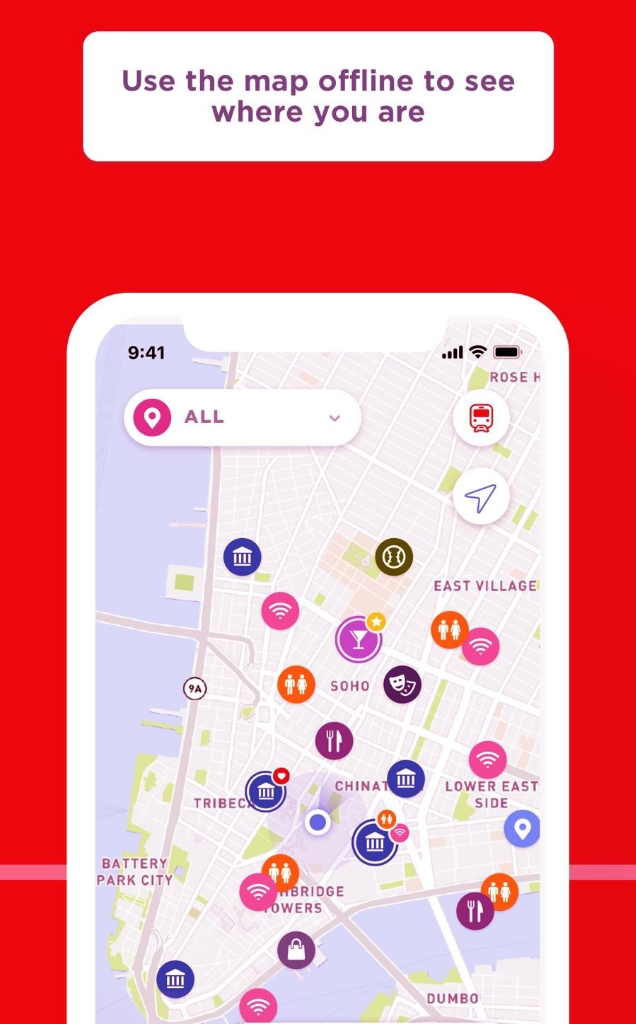
Google Maps is used in the app to display locations and points of interest in the whole territory of New York City. It allows users to explore the map and find the most attractive places.
Location-based Discovery & Filtering
Users can discover nearby places and services in categories such as museums, sports facilities, nightlife facilities, restaurants, shopping facilities, parks, grocery stores, WiFi locations, toilet locations, and family-friendly places. The filtering feature helps users to select places according to their needs.
Offline Subway Map
It is possible for users to download subway map data with an internet connection and then use the downloaded data in offline mode to receive the necessary transportation information.
Key Benefits
-
Consolidate all travel information about NYC into one app
-
Make it possible to discover locations using maps
-
Help visitors find interesting places close by
-
Filter locations by categories
-
Make it possible to use an offline subway map
-
Discover and book events nearby
-
Decrease reliance on a consistent internet connection
Key Features
Interactive Google Map
Create an interactive map and show different locations and points of interest in New York City to aid the user in exploring the city.
Subway Map
Show a separate map related to the subway system of New York City, which can also be downloaded by the user.
Points of Interest
Help the user explore numerous points of interest, including attractions, sports facilities, museums, entertainment, restaurants, shopping centers, parks, public toilets, Wi-Fi spots, kid-friendly locations, and grocery stores.
Location Filters
Help the user to filter the list of locations based on the type they are interested in.
Nearby Places
Show the user the list of useful places and points of interest based on their current location.
Events
Show nearby events and allow the user to discover activities organized in New York City.
Ticket Booking
Allow the user to book tickets for some events from within the mobile application.
Offline Availability
Allow the user to download the content of the application when connected to the Internet and use it in offline mode.
Traveler-Friendly Navigation
Integrate the city information, maps, subway system, and points of interest into one solution.
Technology
| Frontend | Objective-C |
| Backend | Objective-C |
| Database | SQLite |
| Platform | iOS |
| Maps & Navigation | Google Maps |
| Development Tools | Xcode, XTool |
Business Results
30%
Improved Travel Information Accessibility
Centralizing attractions, services, transportation information, and points of interest made essential city information easier for travelers to access.
40%
Faster Location Discovery
Interactive maps, nearby locations, and category-based filters helped users find relevant attractions and services more efficiently.
35%
Improved Navigation Convenience
Google Maps integration and offline subway map access provided travelers with convenient navigation support throughout their journey.
25%
Reduced Dependency on Internet Connectivity
Offline content and subway map functionality allowed users to continue accessing important travel information even without an active internet connection.
Product Gallery
Planning a Similar Mobile App Project?
Whether you’re building from scratch, modernizing an existing application, or expanding your engineering team, our experts are ready to help.
- 450+ Engineers
- 14+ Years
- Flexible Engagement
- US Business-Hour Collaboration
Frequently Asked Questions
The City Guide App is a travel mobile application that helps visitors explore New York City by providing them with maps, points of interest, events, subway information, and offline information.
Users can look up attractions, stadiums, museums, nightlife, restaurants, shopping centers, parks, public bathrooms, WiFi places, family-friendly places, groceries and any other points of interest.
Yes, the application uses Google Maps to display places and navigate in New York City.
Yes, the user may download the subway map when connected to the internet and view it later offline.
Yes, users can view a list of events that take place near their current location and purchase tickets for them using the application.
Yes, users can download offline content from the application when there is an Internet connection.
The application was developed on iOS, using Objective-C as the programming language and SQLite as the database management system.